Options Dialog Box - Hydraulic Model Tab
This tab contains miscellaneous settings. You can set pipe length calculation, spatial reference, label display, and results file options in this tab.
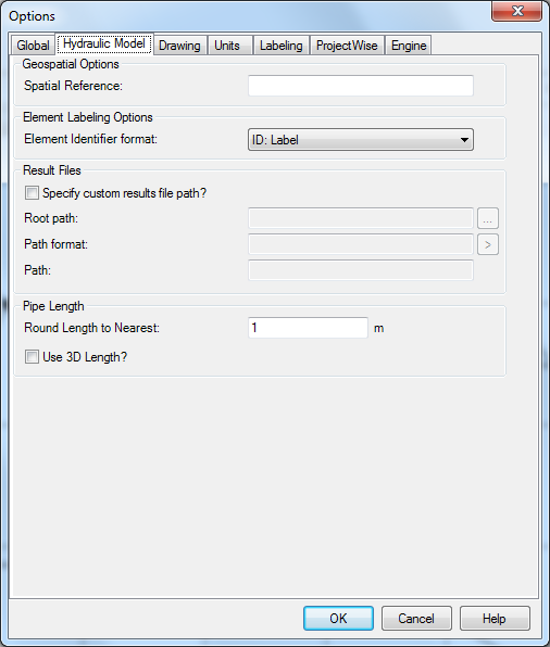
The Hydraulic Model tab contains the following controls:
| Geospatial Options | |
| Spatial Reference | Used for integration with Projectwise. Can leave the field blank if there is no spatial information. |
| Element Identifier Options | |
| Element Identifier Format | Specifies the format in which reference fields are used. Reference fields are fields that link to another element or support object (pump definitions, patterns, controls, zones, etc.). |
| Result Files | |
| Specify Custom Results File Path? | When checked, allows you to edit the results file path and format by enabling the other controls in this section. |
| Root Path | Allows you to specify the root path where results files are stored. You can type the path manually or choose the path from a Browse dialog by clicking the ellipsis (...) button. |
| Path Format | Allows you to specify the complete path that you wish to use for storing your result files for the current hydraulic model. You can type the path manually and/or use predefined attributes from the menu accessed with the [>] button. One of the predefined choices is the Root Path. It is recommended that you start building your Path Format with this Root Path choice. Then optionally extend this path with the other predefined choices. |
| Path | Displays a dynamically updated view of the custom result file path based on the settings in the Root Path and Path Format fields |
| Pipe Length | |
| Round Pipe Length to Nearest | The program will round to the nearest unit specified in this field when calculating scaled pipe length |
| Calculate Pipe Lengths Using Node Elevations (3D Length) | When checked, includes differences in Z (elevation) between pipe ends when calculating pipe length. |